[vc_row css=”.vc_custom_1510949303690{padding-top: 20px !important;}” content_width=”container” video_autoplay=”true” video_controls=”true” video_mute=”true”][vc_column width=”1/3″][vc_widget_sidebar sidebar_id=”archives”][/vc_column][vc_column width=”2/3″][special_heading title=”Odisha ” subtitle=”Areas of Operation in Kandhamal District” animated=”no” font=”secondary” margin_bottom=”30″][vc_column_text]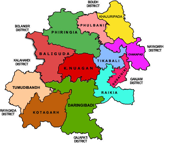
[/vc_column_text][vc_column_text]
| State: Odisha | |
| District: Kandhamal | |
| Peoples Organisation – Jeebika Suraksha Manch | |
| KANDHAMAL DISTRICT PROFILE | |
| ADMINISTRATIVE SETUP | |
| Area | 7649 sq km |
| Blocks | 12 |
| Tehsils | 12 |
| Villages | 2,515 |
| Gram Panchayats | 153 |
| Rural/Urban Ratio | 6.71/5.93 |
| DEMOGRAPHY | |
| Population | 731,952 |
| Sex Ratio | 1,037 |
| Children (age 0 – 6 years) | 109,709 |
| Average Family Size | 5 |
| No of Aganwadi’s Centre / Mini AWC’s | 1264/663 |
| No of Primary Health Centres / Sub Centers | 33/172 |
| Infant Mortality Rate | 169 |
| Maternal Mortality Rate | 142 |
| Literacy | 64.13 |
| ECONOMY | |
| HDI | 0.389 |
| GDP | 0.372 |
| Percapita Income Rs | 4,743 |
| Per capita- state | 5,264 |
| Forest Cover | 5,709.83 sq km |
| Industrial Units | None |
| Irrigated Area | 254.62 sq km |
| Affected by Left Wing Extremism | Yes, High |
| MGNREGA DATA 2017-18 AS ON 18.09.2017 | |
| No. of Families who got work | 50,501 |
| Average No. of Person Days | 31.92 |
[/vc_column_text][/vc_column][/vc_row]