Difference between Cyclone, Hurricane and Typhoon:
They are all same, officially known as tropical cyclones. Tropical Cyclone is known by different names in different geographical location, such as Hurricane in Atlantic and Caribbean Sea, central and northeast Pacific and Typhoons in North West Pacific. It is known as Cyclone in Bay of Bengal and Arabia Sea.
Hence difference between a hurricanes, cyclone and typhoon are simply a matter of location. If the strength of the storm is not too intense, we call them tropical depressions or tropical storms. However if the speed The Saffir -Simpson Hurricane Wind Scale is a 1 to 5 rating based on a hurricane’s sustained wind speed. This scale estimates potential property damage. Hurricanes reaching Category 3 and higher are considered major hurricanes because of their potential for significant loss of life and damage. Category 1 and 2 storms are still dangerous, however, and require preventative measures. In the western North Pacific, the term “super typhoon” is used for tropical cyclones with sustained winds exceeding 150 mph or 241 km/h.
History of Tropical Cyclone in India:
Twenty-six of the thirty-five deadliest tropical cyclones in world history have been Bay of Bengal storms. During the past two centuries, 42% of Earth’s tropical cyclone-associated deaths have occurred in Bangladesh, and 27% have occurred in India. The Orissa Cyclone of 1999 bottomed out at 912 mb (26.93”) and was the most intense such to strike India in at least the past 35 years or so (note that Phailin has apparently become even more intense if the 910 mb figure estimated by satellite stands). The death toll of the 1999 storm of over 9,000 was the greatest in India since the so-called Devi Taluk cyclone that killed 14,200 in Andhra Pradesh State north of Chennai (Madras) on November 12.
Most of the deadliest tropical storms on earth have occurred in the Bay of Bengal when tremendous storm surges have swamped the low-lying coastal regions of Bangladesh, India, and Burma. The worst of all was the Great Boha Cyclone of November 12-13, 1970 when a 40-foot storm surge overwhelmed the delta islands of the Brahmaputra and Ganges Rivers in Bangladesh. An estimated 300,000-500,000 perished. This storm is also considered to have produced the greatest storm surge of any Indian Ocean cyclone although similar surges may have occurred during the 1733 and 1876 cyclones.
Rationale behind Choosing Predetermined Name:
The practice of naming storms (tropical cyclones) began years ago in order to help in the quick identification of storms in warning messages because names are presumed to be far easier to remember than numbers and technical terms. Many agree that appending names to storms makes it easier for the media to report on tropical cyclones, heightens interest in warnings and increases community preparedness.
In India, RSMC tropical cyclones New Delhi will give a tropical cyclone an identification name from the above name list. The identification system covers both the Arabian Sea and the Bay of Bengal. Names only started to be assigned to Tropical Cyclones in the North Indian Ocean in October 2004 with the first one named as Onil.
Cyclone Season in India:
The North Indian Cyclone Season begins in April and lasts until June. There is typically another heightened period of activity from late September to early December.
Phalin:
Phailin is the Thai word for sapphire and according to the followed procedure of naming tropical cyclones over north Indian Ocean it was turn of a name suggested by Thailand in the list of assigned names. The next cyclone in the region will be called Helen, a name from the list of cyclone names given by Bangladesh.
Phalin was the second-strongest tropical cyclone ever to make landfall in India, behind only the 1999 Odisha cyclone. PHAILIN originated from a remnant cyclonic circulation from the South China Sea. PHAILIN crossed Odisha & adjoining north Andhra Pradesh coast near Gopalpur (Odisha) around 2230 hrs IST of 12th October 2013 with a sustained maximum surface wind speed of 200-210 km/h gusting to 220 km/h). It subsequently weakened over land as a result of frictional forces, before it was last noted on October 14, as it degenerated into a well marked area of low pressure. Hence due to low pressure, it caused very heavy to extremely heavy rainfall over Odisha leading to floods, and strong gale wind leading to large scale structural damage and storm surge leading to coastal inundation over Odisha. Maximum rainfall occurred over northeast sector of the system centre at the time of landfall. Maximum 24 hr cumulative rainfall of 38 cm was reported Odisha.
Preventive measures of Central and State Government
Entire world has appreciated Odisha government effort to evacuate huge population before Phalin would have hit the shore. As part of the preparations, 600 buildings were identified as cyclone shelters and people were evacuated from areas near the coast, including Ganjam, Puri, Khordha and Jagatsinghapur districts in Odisha. The cyclone prompted India’s biggest evacuation in 23 years with more than 550,000 people moved up from the coastline in Odisha and Andhra Pradesh to safer places. The Odisha Government claimed that over 4.55 lakh people were evacuated from low lying areas in the districts of Ganjam, Puri, Kendrapara, Jagatsinghpur, Bhadrak, Balasore, Cuttack, Nayagarh and Gajapati and kept in safe shelters,
Due to early warning of IMB the government of Odisha issued a high alert to number of district i.e.Balasore, Bhadrak, Mayurbhanj, Keonjhar, Dhenkanal, Jajpur, Cuttack, Jagatsinghpur,Kendrapara, Puri, Khurda, Nayagarh, Ganjam and Gajapati, and cancelled the Dusshera holidays of employees of all 30 districts of the state, asking them to ensure the safety of people. Food and relief materials were stocked-up at storm shelters across the state. Distant storm warning signal was raised to two at the ports of Paradip and Gopalpur of the state. Defense personnel, particularly the Air Force and Navy were also deployed for rescue and relief operations. Odisha government had made arrangements for over 1,000,560 food packets for relief.] Indian Air Force helicopters were kept on standby in West Bengal to move in for help at short notice. While as many as 9.83 lakh people were evacuated to safer places ahead of the storm, around 1.12 lakh people of five districts were shifted before the floods. As per state “Revenue and Disaster Management ” statistics , two crore people in 16,487 villages and another 43 urban bodies in 17 blocks were affected due to the cyclone as well as floods which has hit 17 out of 30 districts in the state. Moreover, 3.76 lakh houses either fully or partially damaged in both Phalin and flood.
Role of Government after Cyclone
Though the state government, in two separate memoranda to the Centre, had demanded Rs 5832.50 crore for assistance from the NDRF, it has received only Rs 1,000 crore (Rs 750 from NDRF and Rs 250 crore from SDRF). The role of Odisha government was commendable in timely evacuation of approximately 10 lakh people to safer places. This resulted few casualty despite the gravity of Phalin. However they have failed in appropriate rehabilitation aftermath of flood. They received a fund of Rs 1,000 crore (Rs 750 from NDRF and Rs 250 crore from SDRF). However opposition had criticized Naveen Patnaik government for insensitive handling of rehabilitation work after flood in Odisha. Infact Media was reported that people had no option but to shift out from their homes. Thousands of people had no option but to shift out from their homes in a hurry with whatever belongings they could carry in their hands.
Odisha Disaster management Authority
The concept of disaster management has undergone a paradigm shift from relief, restoration and rehabilitation to planning, preparedness and prevention. In addition to this, the concept of multi-stakeholder approach involving Government, International and local NGOs, Civil Society and the community is given a concrete shape by addressing the complex issues of disaster management in the State.
The Government of Orissa is implementing the Disaster Risk Management (DRM) programme in 16 disaster-prone districts in order to reduce the vulnerabilities in two phases from 2002-08 with the support of the Government of India (Ministry of Home Affairs) and the United Nations Development Programme (UNDP). This Programme is also implemented in 16 other states. Prior to this, UNDP sponsored Community Based Disaster Preparedness (CBDP) programme was implemented in ten blocks of seven coastal districts on pilot basis. The overall goal of the programme is “Sustainable Reduction in Disaster risk in some of the most hazard-prone districts”. Ganjam is one amongst the 16 district, covering 13 blocks, 292 GPs and 1423 Villages.
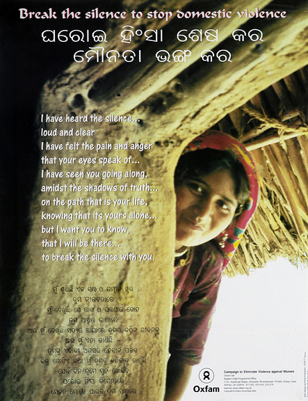
Role of NGOs in Disaster Mitigation
Oxfam
Oxfam and partners have had an on-going presence in the Odisha, supporting them with initiatives like public hygiene promotion and village cleaning.
1. Oxfam has supported paddy and vegetable seed inputs support to 1100 poor farmer households in 19 villages in balasore district.
2. Supplementary food support to 1220 lactating mothers in Balasore district
3. 485 beneficiaries identified under Cash for Work Programme in Puri and Ganjam districts
4. Hygiene kits distributed to 4369 households in Puri, Ganjam and Balasore districts
5. Oxfam had conducted 4192 Public Health Promotion campaigns including household visits, awareness generation programmes and village cleaning drives.
6. They have also distributed emergency shelter kits to 4340 households
Oxfam India is actively working to restore livelihoods, revive education, re-establish public health systems and strengthen community based organizations.
Save the Children
Save the Children supported 1000 families, through health and hygiene kit, food baskets and tarpaulin sheets. Oxfam also distributed non food items to the worst hit villages in Ganjam and Puri district – which consist of emergency shelter materials (tarpaulins, ground sheets and ropes), solar lantern with mobile charger, hygiene kit and additional dry food distribution.
Save the Children has been working in Odisha implementing disaster preparedness programmes from 2007 onwards and it works with communities, including schools and children, to prepare them to play an active role in disaster management. They were on the ground supporting the administration in evacuation even during the cyclone. They are also providing support to the government and NGO partners to respond to any needs emerging from the cyclone for affected people.
Ganjam Disaster response Forum (GDRF)
Phalin has also led to the formation of the Ganjam Disaster Response Forum (GDRF), a body of 15 NGOs of Ganjam district got together on October 10 and extended their support to the administration in evacuation and other services as part of cyclone preparedness. Under a UNICEF supported project GDRF had taken up water and sanitation assessment in 141 villages of the district. Basing on this report with assistance of the district administration, the GDRF has taken up the mantle to completely stop open defecation in 76 villages of 44 panchayats in the district.
Cyclone Proofing Methods:
Sea Wall and Embankments:
Sea walls and saline water embankments are considered the most structurally effective and capital intensive method to mitigate the risks of cyclones. A seawall is a coastal defense constructed usually of reinforced concrete on the inland part of a coast to prevent the ingress of storm surges arising out of cyclones. Sometimes the sea wall is constructed with a multiple purpose of reclaiming low lying land or preventing coastal erosion. The height of sea walls is determined according to the maximum observed height of storm surges which may be as high as 10 meters. Therefore sea walls are usually massive structures which can be built only with a heavy investment. Maintenance of such structures further requires recurrent expenditure. Hence sea walls along the entire coast are never a practicable solution to prevent or mitigate storm surges, but such walls are recommended when valuable assets like a city or a harbor is to be protected. Sea walls can be vertical, sloping or curved. Modern concrete seas walls tend to be curved to deflect the wave energy back out to sea, reducing the force. There are instances of many sea walls which were constructed after devastating cyclones and which successfully prevented such disasters. The most important is the 12 Km long and 17 ft high seawall constructed in Texas after the Galveston Hurricane of 1900 which killed 8000 people. The seawall has never been overtopped by a storm surge from a hurricane, although maintenance of the wall has been beset with various engineering problems. The Gold Coast seawall in
Australia was laid along the urban sections of the Gold Coast coastline following 11cyclones in 1967. The massive stone seawall in Pondicherry constructed and maintained by the French engineers kept the historic city center dry even though tsunami waves of December 2004 had driven water 24 feet above the normal high tide mark. Similarly 3.5 meter high sea wall in Maldives saved the city of Male from the tsunami. Such success stories are available from many coastal cities. There are also instances where absence of such protective structures near the beaches and resorts and breaches in sea walls near the cities and towns resulted in severe damages to life and property. If sea walls are essential to protect coastal cities and harbors, saline water embankments are recommended to protect rural settlements and to prevent saline water ingress into agricultural and horticultural land. Such embankments are usually a ridge built with earth or rock to contain the storm surges. Cost benefit calculations usually do not permit very high specifications for such constructions and therefore effectiveness of such embankments in preventing or mitigating the impacts of cyclones have been rather limited. Further, saline embankments have the potential to kill the mangroves due to chocking of saline water. Therefore such embankments should be constructed in limited areas where vegetative protection would not be adequate to prevent the ingress of saline water into habitations.
Bio-Shields
Bio shields usually consist of mangroves, casuarinas salicornia, laucaena, atriplex, palms, bamboo and other tree species and halophytes and other shrub species that inhabit lower tidal zones. These can block or buffer wave action with their stems, which can measure upto 30 meter high and several meters in circumference. They trap sediment in their roots; thereby maintain a shallow slope on the seabed that absorbs the energy of tidal surges. They also break the high velocity of winds and thus protect agricultural crops and shelters besides providing shelter and grazing lands for the livestock and farms. They reduce evaporation from the soil, transpiration from the plants and moderate extreme temperatures. They protect fertile coastal agricultural land from erosion. They also serve as carbon sinks as they help enhance carbon sequestration which makes coastal communities eligible for carbon credit to earn additional income. Besides they promote sustainable fisheries by releasing nutrients in the water.
Unfortunately the multiple and long term environmental protection and economic functions of the bio-shields have not been adequately appreciated until very recently. Unabated anthropogenic pressures of coastal settlements and unchecked commercial exploitation of coastal resources have resulted in denudation of such natural buffers exposing large areas to the vagaries of cyclonic storms. In Orissa, where the low-lying coastline has been stripped of mangroves to make way for shrimp farms, the super cyclone of 1999 left more than 10,000 people dead and around 7.5 million homeless. Although the cyclone affected over 250 km of Orissa’s coastline, it was only the highly denuded area of 100 km through which water surged. Other areas with intact mangrove forests were largely unaffected. Again the Indian Ocean tsunami of 2004 impacted those areas more severely where the bioshields buffer were either not available or depleted considerably. In such areas tsunami waves made deep ingress into land, ruined crops, drowned livestock and poisoned arable land and water supplies with salt. Mangroves and other coastal habitats, where still in existence, met the tsunami head on. For instance, the Pichavaram mangrove forest, a tourist attraction in Cuddalore district, protected about 6,000 people living in six hamlets located between 100 meters and one kilometer from the mangroves. Seawater did not enter the village and hence there was no loss of property. Therefore systematic regeneration of the bio-shields in the coastal belts wherever feasible is the most natural and cost effective method of protecting these areas from storm surges and erosion. This is not an easy task which can be achieved instantly since there is a time cycle for such plantations to grow and survive against fresh pressures of winds and waves. Therefore serious efforts are required in designing such bio-shields, selecting the appropriate fast growing species suitable to the agro-climatic zones and involving the coastal communities in the maintenance and protection of such buffer zone of plantations.
Study of “Saudamini Das and Jeffrey R. Vincent”, has also revealed the positive impact of mangroves on such disaster. As per their statistical data, bioshield had significantly reduced the number of deaths during the 1999 cyclone that struck the eastern coast of India. They revealed that the beneficial effect was mainly due to mangrove vegetation, not physical characteristics of mangrove habitat. Human impacts on the ecosystem (i.e., deforestation) thus affected the death toll. Deforestation of the coastal mangroves in the storm surge zone was associated with increased death toll in that storm, according to Das and Vincent (2009), who concluded, “villages with wider mangroves between them and the coast experienced significantly fewer deaths than ones with narrower or no mangroves”.
Cyclone Shelter
A large number of people in the coastal areas live in thatched houses which cannot withstand the high velocity of wind and storm surges resulting in extensive damages of such houses and deaths and injuries of a large number of poor people. The high rates of casualties in cyclones in Bangladesh and India are primarily due to unsafe buildings in the coastal areas. The poor economic conditions of the people may not permit them to rebuild their houses as per the cyclone resistant designs and specifications. Therefore, community cyclone shelters constructed at appropriate places within the easy access of the habitations of the vulnerable communities can provide an immediate protection from deaths and injuries due to the collapse of houses. Such shelters are usually built on pillars above the danger level of storm surges/inundation, are specious enough to accommodate a few hundred people of the neighboring hamlets and provide provisions of drinking water, sanitation, kitchen, etc.
During the normal season such shelters can be utilized as schools, dispensaries or other community purposes. A large number of such cyclone shelters were built in the coastal areas of Bangladesh and eastern and south India, which provided immediate shelters to the vulnerable communities. Drastic reduction in the number of deaths and injuries in the cyclones during the past 5-6 years can be partly attributed to these shelters. Therefore, the governments have placed a very high priority on the construction of such shelters in areas which have hitherto not been covered.
Field Visit Report
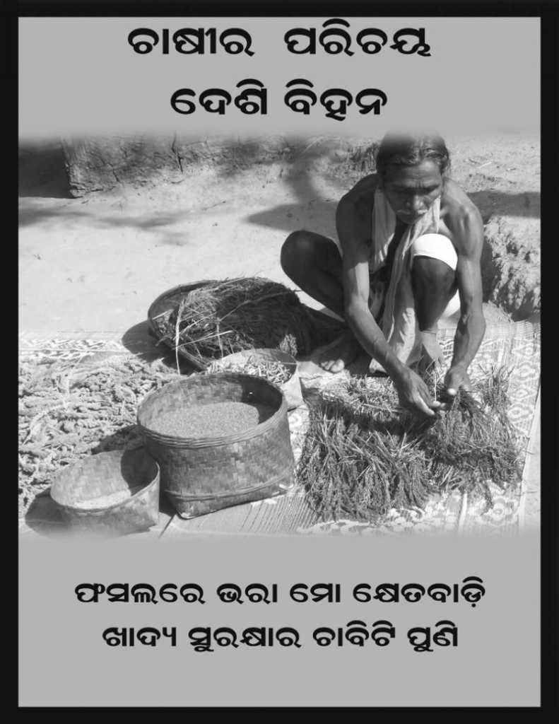
Objective of the visit was to have an overview of Atmashakti’s rehabilitation work in Ganjam district; to have firsthand experience of the region; direct interaction with farmers (beneficiaries); follow up with farmers to pay back as per the contract. As per the well thought strategy we helped the poorest of poor through ‘food for work’ and ‘seeds for cultivation’. We have reached 2892 Household in 52 villages in Ganjam District. Whereas we distributed Vegetable, and ground nut seeds; so that people can immediately restore their livelihood.
Atmashakti has raised fund from their respective donors and spent them on rehabilitation work in Odisha. As per the strategy Atmashakti team has decided to distribute the seeds for cultivation; however farmers have to pay back the same quantity of seeds after cultivation of their respective crops. In the case of vegetable seeds farmers have to pay back the cash amount, equals to the seeds given to them. While in ‘food for work’, we have help the farmers to construct or build their houses, in return we have given them 10 kg of Rice and 1 kg of Dal. Though it was free of cost, however as per the strategy we have distributed Rice and Dal in four installments, so that we can monitor whosoever is not working should not be given or eligible for next installment of food supply. We have decided to collect the fund in the form of seed from the beneficiaries, so that we would have continued with such funds as an ‘emergency fund’ in natural disaster or any other emergency.
Amount spent on seeds are as follows:
| # | Seeds | Amount (lakh) |
| 1 | Rice | 0.98 |
| 2 | Dal | 0.29 |
| 3 | Leaf Vegetable | 1.05 |
| 4 | Vegetable Seeds | 0.81 |
| 5 | Moong | 5.20 |
| 6 | Ground Nut | 18.85 |
| Total Amount | 27.18 |
As per the plan, Atmashakti team has decided to visit Ganjam district in order to see the status of crops and the progress of the collection in respective villages. Team of Amir, Shantanu and Aruna has visited Ganjam district on 9th to 10th March 2014 respectively.
Details of the visit are as follows:
Day1, 09.04.2013
We have visited Hundata Totasahi, village of 11 household, primarily inhabited by Dalits. We helped whole village i.e. 11 household, to build their houses under ‘food for work’ programme.
After 15 minutes journey from former village we reached Hundata, village predominantly inhabited by Dalit, OBCs and tribals. We have distributed ground nut seeds to 133 household under ‘seed for cultivation’. Bishwajeet, one of the beneficiaries took us to the field, wherein we have also met other beneficiaries. As per the farmers crop was alright, however there is some insect related problem in crop, hence we have advised them to escalate the matter to respective block office for help. Farmers also assured us that they will give us the seeds once crop is harvested. We have spent Rs. 150480, we needs to be collected after cultivation of ground nut crops.
We have visited New-Burapada, where we have supported 27 household in ‘food for work’ programme. Later, we went to Burapada, where we have supported total 119 families, in which 18 families were supported under food for work and 101 household under seeds for cultivation programme. Atmashakti gave vegetable seeds of RS. 76518, wherein we distributed the seeds of brinjal, lady finger, cauli flower, cabbage, chilli, long beans, capsicum, tomato etc. Gangaram, one of the beneficiary and volunteer took us to the field. He has mentioned that crop has come really good and he would facilitate the collection from his village.
We have also gone to bharatpalli, block-Aska, wherein we helped 7 household in both food for work. We have also visited Kanjiama, village of 400-500 household predominantly inhabited by Dalit, OBC and tribals. In Kanjiama paddy crop was 100% destroyed, thus we supported 133 household through s’eed for cultivation’ programme. We did manage to meet Committee president, Lingaraja’s son, who accompanied us to the field, wherein we also met farmers who also mentioned about some problem in ground nut crop.
Second Day Visit, 10.03.2014
Second day we have gone to block Beguniapada, wherein Sharad Pandi, local leader accompanied us to Hansadeuli. It is a village of 450 household with mixed population of dalit, tribals and OBCs. Seeds of and ground nut were given to 87 household. People of the village were very happy and enthusiastic about good productivity of both crops. Infact, cultivation was also started in most of the villages. From there we headed to Bhabanipur, village of 84 household beneficiaries. We went to the field with the beneficiaries farmers and it was noticed that ground nut crop was really good and farmers were also very positive about the good yield. We have also visited Chatarpur block, baranga, village of 465 total household with 182 household beneficiaries. Mojority of village people were dalits, OBCs and tribals.
We have also met Bhaskar, committee member of village karapada, Block – Ganjam. In Karapada we have supported 79 household under seed for cultivation programme. Aruna had discussed the status of the collection of green leaf vegetable (Saag) cultivation. Bhaskar has informed us that he has collected Rs.1552 against Rs.12640. Simultaneously, we have visited Biripuri, block – ganjam, in order to see the status of the collection of Saag Cultivation. In Biripur we have met committee president, Bipra Charandas and committee member Trinath Das. They have explained that some of the beneficiaries are reluctant to pay back the amount. However, Aruna tried to sensitize them about the process and system of revolving fund. Why it is important for them to pay back. He also told them about Atmashakti effort to arrange pottery wheel for potters in same respective village. He also categorically stated that if the village does not pay back from cultivable crop, then we have to rethink our decision regarding pottery wheel. After the brief conversation, village committee president has assured us that he would be convening meeting today with village people and escalating the issue to the responsible people. He also assured that he will try his best to collect the money from villagers. As of now we have collected Rs.6841 against Rs.21760.
We also had a meeting with Jay krishan Charty, Alliabad Village wherehave supported 66 Household by distributing Saag seed. Rs 10,000 is already been collected against RS.10880. However 19 seeds packet are still lying with him.
Cultivation of Moong:
Moong beans prefer well-draining soil with lots of sand or loam. Moong beans do not fare well in clay soils, poor-draining soils or overly wet soils. Moong beans are a full-sun crop, needing at least six to eight hours of sun per day. They also need 90 to 120 days of frost-free growing conditions to ripen. Moong bean seeds are small and delicate; they could be broken by careless handling. Moong beans should be planted 1 1/2 inches deep in rows spaced two feet apart, with up to nine Moong beans seeds planted in each row per foot. Moong beans prefer deep watering occasionally, rather than frequent and short watering. Moong beans do not tolerate waterlogged or muddy soil conditions.I t also does not need tilling and fertilizer, moreover burden of irrigation is also negligible on farmers.
Ground Nut:
Groundnut is an easy-to-grow crop, as long as one can provide the right growing conditions and climate. A warm-weather plant, peanuts require a long, hot growing season, loose sandy soil to develop in and careful adherence to watering requirements. Rainfall is critical to a peanut crop, particularly during the flowering period. Flowers emerge six to eight weeks after the plant breaks ground. Once the flower is fertilized, it drops off and the remaining stem curves downward and penetrates the soil. This process takes about 10 days. During this period, the peanut plants should receive a good soaking, to a depth of 6 to 8 inches each week. If rainfall is not adequate, water must continue to be supplied after flowering. If the peanut plants are allowed to dry out after flowering, the crop will be reduced, perhaps substantially.
While it is important that the plants receive adequate rainfall or irrigation, too much watering can be harmful. Over-watering can cause the nuts to sprout in the ground. A weekly watering of 4 to 6 inches should be adequate for most home gardens. As harvest time draws near, pay attention to weather forecasts. Sudden and heavy rains just before harvest can also cause the nearly mature nuts to begin sprouting.
Observation:
Gravity of devastation was very visible during the train journey from Bhubaneswar to Berhampur. Some of the farm fields are still full of sands, trees, houses were badly affected. After reaching Behrampur, we took a taxi to visit number of planned villages; it was journey of 2 hours from residing hotel and during the journey Aruna has pointed out several fields full of sands, destroyed trees of Beetle nuts, cashew, Kewda, Coconuts, Mangoes etc. The gravity of natural disaster has really shaken my inner conscience, because so far I never had a direct experience and exposure to such natural disaster. The tussle and debate regarding defining poverty in planning commission office, parliament and prime time news channel programme seemed useless, when I actually seen the situation of people living in Ganjam District. People were literally living in air tight houses, defecating on roads, health centers were not operating properly. People have grievances that government health center are not working properly, hence their health cards is of no use.
Irrespective of socio-economic and political challenges, number of positive things were also observed and noticed in Ganjam district. Children were going to schools; especially girl child presence was very overwhelming. However majority of people are still defecating openly, thus we need to sensitize them towards its consequences on health. Moreover they also need to be sensitized towards water and sanitation.
It was also observed that social fabric of rural Odisha was commendable; people are living in social harmony. Thus urban India should also learn the syncretic culture of that region, as well how to live in peace and harmony without castigating any particular community.
Impact of our intervention at right time was very much visible. Beneficiaries themselves accepting that if we would have not intervened, thing would have worst there. In almost all villages crops are in good condition, farmers are expecting good output and they have also assured us to pay back on time.
Conclusion:
The gravity of devastation was directly experienced through field visit. People have also narrated the incident of flood and its impact aftermath. Diversity was clearly observed from Koraput to Ganjam, indeed every village has different dynamics. The level of poverty was really disappointing and people are struggling everyday for their survival.
The families we have covered under the both programmes were poorest of the poor. Majority of people were either landless farmers or small farmers with 1 to 2 acres of land. As these people were badly affected by Phalin . Hence Atmashakti timely intervention tried to help such people through ‘seed for cultivation and food for work programme’. We have facilitated jobs under MGNREGA programme , so that people would clear sand from their respective field . Later we distributed seed, so that they can start farming and have some sort of relief. The quantifiable impact is very much visible, however the qualitative impact can only be observed once you directly go and meet the beneficiaries.
The idea of revolving fund is very constructive and we would certainly continue with such funds for natural disaster or any other emergencies in future. Hence, we need to do rigorous follow up, so that we can collect revolving fund from farmers. Now farmers have started cultivated, thus we need a follow up wherever we have distributed seeds. Simultaneously we need to keep an eye on vegetables and ground nut crops, as per the time of their harvesting.